Background
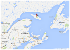
Anticosti Island (49°30′N 63°00′W), nicknamed the ‘Pearl of the St. Lawrence’ is located in the Gulf of St. Lawrence and is approximately 225 km in length, and 56km at its widest point (Figure 1). It covers approximately 7,943km2 in terms of land area and is features vast landscapes, rich wildlife, and a sparse human population. Given its location at the mouth of the St. Lawrence seaway and the Gulf leading to the Atlantic Ocean, the island lies along a core navigation route and has over the centuries had a number of shipwrecks wash upon its shores (Figure 2).
Features
Anticosti has three major protected areas where all industrial areas have been off limits. These areas include one national park (Parc National d’Anticosti) and two ecological reserves, the Grand Lac-Salé and the Pointe-Heath, protected for their unique biodiversity and geological features. Access to these areas is strictly forbidden, except in cases of scientific research or for educational purposes. The majority of the island is categorised as habitat for fauna, including migrating birds, deer, bison, caribou, red fox, otter, elk, mink, moose, grey seals, muskrat, black bears, and the highly vulnerable atlantic salmon, among others. Additionally, more than 600 species of prehistoric fossils have been found on the island, including species of brachyopods, cephalopods, marine gastropods and trilobites.
Click here for the factsheet (4 pages): FS_038_Anticosti Island
The project ENVJUSTICE has received funding from the European Research Council (ERC) under the European Union’s Horizon 2020 research and innovation programme (grant agreement No. 695446)